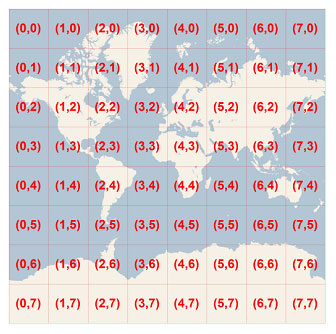
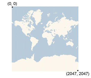
 Given a pair of pixel XY coordinates, you can easily determine the tile XY coordinates of the tile containing that pixel:
tileX = floor(pixelX / 256)
tileY = floor(pixelY / 256)
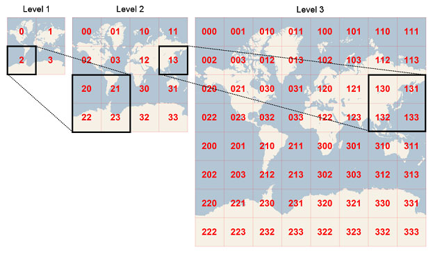
To optimize the indexing and storage of tiles, the two-dimensional tile XY coordinates are combined into one-dimensional strings called quadtree keys, or “quadkeys” for short. Each quadkey uniquely identifies a single tile at a particular level of detail, and it can be used as an key in common database B-tree indexes. To convert tile coordinates into a quadkey, the bits of the Y and X coordinates are interleaved, and the result is interpreted as a base-4 number (with leading zeros maintained) and converted into a string. For instance, given tile XY coordinates of (3, 5) at level 3, the quadkey is determined as follows:
tileX = 3 = 011 2
tileY = 5 = 101 2
quadkey = 100111 2 = 2134 = “213”
Quadkeys have several interesting properties. First, the length of a quadkey (the number of digits) equals the level of detail of the corresponding tile. Second, the quadkey of any tile starts with the quadkey of its parent tile (the containing tile at the previous level). As shown in the example below, tile 2 is the parent of tiles 20 through 23, and tile 13 is the parent of tiles 130 through 133:
 Finally, quadkeys provide a one-dimensional index key that usually preserves the proximity of tiles in XY space. In other words, two tiles that have nearby XY coordinates usually have quadkeys that are relatively close together. This is important for optimizing database performance, because neighboring tiles are usually requested in groups, and it’s desirable to keep those tiles on the same disk blocks, in order to minimize the number of disk reads.
===== Sample Code =====
The following sample C# code illustrates how to implement the functions described in this document. These functions can be easily translated into other programming languages as needed.
//------------------------------------------------------------------------------
// <copyright file="VirtualEarthTileSystem.cs" company="Microsoft">
//     Copyright (c) 2006 Microsoft Corporation.  All rights reserved.
// </copyright>
//------------------------------------------------------------------------------

using System;
using System.Text;

namespace Microsoft.MapPoint
{
    static class VirtualEarthTileSystem
    {
        private const double EarthRadius = 6378137;
        private const double MinLatitude = -85.05112878;
        private const double MaxLatitude = 85.05112878;
        private const double MinLongitude = -180;
        private const double MaxLongitude = 180;


        /// <summary>
        /// Clips a number to the specified minimum and maximum values.
        /// </summary>
        /// <param name="n">The number to clip.</param>
        /// <param name="minValue">Minimum allowable value.</param>
        /// <param name="maxValue">Maximum allowable value.</param>
        /// <returns>The clipped value.</returns>
        private static double Clip(double n, double minValue, double maxValue)
        {
            return Math.Min(Math.Max(n, minValue), maxValue);
        }


        /// <summary>
        /// Determines the map width and height (in pixels) at a specified level
        /// of detail.
        /// </summary>
        /// <param name="levelOfDetail">Level of detail, from 1 (lowest detail)
        /// to 23 (highest detail).</param>
        /// <returns>The map width and height in pixels.</returns>
        public static uint MapSize(int levelOfDetail)
        {
            return (uint) 256 << levelOfDetail;
        }


        /// <summary>
        /// Determines the ground resolution (in meters per pixel) at a specified
        /// latitude and level of detail.
        /// </summary>
        /// <param name="latitude">Latitude (in degrees) at which to measure the
        /// ground resolution.</param>
        /// <param name="levelOfDetail">Level of detail, from 1 (lowest detail)
        /// to 23 (highest detail).</param>
        /// <returns>The ground resolution, in meters per pixel.</returns>
        public static double GroundResolution(double latitude, int levelOfDetail)
        {
            latitude = Clip(latitude, MinLatitude, MaxLatitude);
            return Math.Cos(latitude * Math.PI / 180) * 2 * Math.PI * EarthRadius /
                MapSize(levelOfDetail);
        }


        /// <summary>
        /// Determines the map scale at a specified latitude, level of detail,
        /// and screen resolution.
        /// </summary>
        /// <param name="latitude">Latitude (in degrees) at which to measure the
        /// map scale.</param>
        /// <param name="levelOfDetail">Level of detail, from 1 (lowest detail)
        /// to 23 (highest detail).</param>
        /// <param name="screenDpi">Resolution of the screen, in dots per inch.</param>
        /// <returns>The map scale, expressed as the denominator N of the ratio 1 : N.</returns>
        public static double MapScale(double latitude, int levelOfDetail, int screenDpi)
        {
            return GroundResolution(latitude, levelOfDetail) * screenDpi / 0.0254;
        }


        /// <summary>
        /// Converts a point from latitude/longitude WGS-84 coordinates (in degrees)
        /// into pixel XY coordinates at a specified level of detail.
        /// </summary>
        /// <param name="latitude">Latitude of the point, in degrees.</param>
        /// <param name="longitude">Longitude of the point, in degrees.</param>
        /// <param name="levelOfDetail">Level of detail, from 1 (lowest detail)
        /// to 23 (highest detail).</param>
        /// <param name="pixelX">Output parameter receiving the X coordinate in pixels.</param>
        /// <param name="pixelY">Output parameter receiving the Y coordinate in pixels.</param>
        public static void LatLongToPixelXY(double latitude, double longitude, int levelOfDetail,
            out int pixelX, out int pixelY)
        {
            latitude = Clip(latitude, MinLatitude, MaxLatitude);
            longitude = Clip(longitude, MinLongitude, MaxLongitude);

            double x = (longitude + 180) / 360;
            double sinLatitude = Math.Sin(latitude * Math.PI / 180);
            double y = 0.5 - Math.Log((1 + sinLatitude) / (1 - sinLatitude)) / (4 * Math.PI);

            uint mapSize = MapSize(levelOfDetail);
            pixelX = (int) Clip(x * mapSize + 0.5, 0, mapSize - 1);
            pixelY = (int) Clip(y * mapSize + 0.5, 0, mapSize - 1);
        }


        /// <summary>
        /// Converts pixel XY coordinates into tile XY coordinates.
        /// </summary>
        /// <param name="pixelX">Pixel X coordinate.</param>
        /// <param name="pixelY">Pixel Y coordinate.</param>
        /// <param name="tileX">Output parameter receiving the tile X coordinate.</param>
        /// <param name="tileY">Output parameter receiving the tile Y coordinate.</param>
        public static void PixelXYToTileXY(int pixelX, int pixelY, out int tileX, out int tileY)
        {
            tileX = pixelX / 256;
            tileY = pixelY / 256;
        }


        /// <summary>
        /// Converts tile XY coordinates into a QuadKey at a specified level of detail.
        /// </summary>
        /// <param name="tileX">Tile X coordinate.</param>
        /// <param name="tileY">Tile Y coordinate.</param>
        /// <param name="levelOfDetail">Level of detail, from 1 (lowest detail)
        /// to 23 (highest detail).</param>
        /// <returns>A string containing the QuadKey.</returns>
        public static string TileXYToQuadKey(int tileX, int tileY, int levelOfDetail)
        {
            StringBuilder quadKey = new StringBuilder();
            for (int i = levelOfDetail; i > 0; i--)
            {
                char digit = '0';
                int mask = 1 << (i - 1);
                if ((tileX & mask) != 0)
                {
                    digit++;
                }
                if ((tileY & mask) != 0)
                {
                    digit++;
                    digit++;
                }
                quadKey.Append(digit);
            }
            return quadKey.ToString();
        }
    }
}


